Saturday, August 8, 2009

San Clemente State Beach


San Clemente State Beach appears to be geared towards beach camping and picnicking. There are ample camp sites and summer camp programs for the family as well as covered picnic tables along the bluffs with ocean views and breezes. Getting to the beach from the parking lot is a steep climb down. The experienced beach goers roll their gear along in wagons or loaded down strollers.

Today I got in touch with my “hobo” side. There is a trail that starts along Calafia Beach (San Clemente) and follows the railroad tracks into Trestles Beach in San Diego county (north of San Onofre and Camp Pendleton). I parked at San Clemente State Beach which is in the middle of the trail, mainly because I still have a few days on my state beach park pass, and headed south. I can now say that I have walked to San Diego (county).

The trail is sand and gravel and is about 4 feet from the train tracks. On the other side of the tracks are beautiful beaches. The track crossings are well-marked and one can get back and forth pretty easily (depending on how tired one is from walking in the sand). I estimate that the walk from the state beach to Trestles was about a mile one-way. Going north, it seemed possible to follow the tracks up to the San Clemente Pier and then to end the walk with a bucked of assorted fried sea creatures and cold bubbly beverages.

Sunday, July 5, 2009

Metamorphosis


Several weeks ago, a large number of black spiky caterpillars came out of the community open space, climbed up the house and formed their chrysalides. I have been watching them closely and, on Friday, the butterflies started to emerge. While this weekend was more about relaxing on the patio with a G and T instead of exploring new trails, it was an incredible experience to be able to sit in the yard and watch the butterflies.

This was my first experience with emerging butterflies. I learned several things: (1) it takes about 30 seconds for them to break out of the shell (leaving little time for removing a lens cap or the flash to recharge), (2) it takes several hours of hanging upside down for the wings to unfold and ‘fill’ before flying and (3) the butterfly ‘drips’ bright red ‘stain’ while unfolding, leaving the patio looking like a horror movie set, post-axe murderer.

If you want to see the entire life cycle of the mourning cloak in Orange County, check out Peter Bryant’s website. He has managed to capture the cycle from egg to butterfly and the mob of caterpillars is hysterical (at the very bottom of the web page).


Saturday, July 4, 2009

Jeronimo Open Space, Mission Viejo CA


Jeronimo Open Space parallels Jeronimo Parkway between Olympiad and Arbolitos (the next major cross road is Marguerite Pkwy). There are 2 paved trails, an upper trail and lower trail, that straddle Oso Creek and are each about 1 mile one-way. The trail is well-used by the locals for strolling, dog walking, running and casual biking. If you are driving in, there is street parking at Pavion and Jeronimo, along Pavion Park. If you are bringing kids, Pavion Park has nice playground and grassy areas for running down little kid ‘batteries’.

The open space runs through established neighborhoods and there is a lot of human and dog traffic. I have not seen many ‘beasts’ along this trail but there has been some recent habitat restoration activities. Hopefully, wildlife will follow!

Sunday, June 28, 2009

Sienna Botanica


“No Dumping, Drains to Ocean”, “Make a Splash, Curb Urban Run-Off” are the messages found in our South Orange County neighborhoods. Run-off water from our homes is full of nutrients from landscaping, pet waste, oil and other urban contaminants that drain directly into the creeks and then to our beaches. Every year, beaches are routinely closed due to the high levels of pollution caused by urban run-off.

Wetlands serve to act as a natural biofiltration system to protect the ocean however most of the wetlands have been destroyed by being ‘tamed’ into cement riverbeds for flood control or dredged for marinas. Several communities have been successful in recreating marsh-like systems for capturing run-off to naturally filter and clean the water before it is released into the watershed. Today, we rode along Sienna Botanica, a smaller man-made natural biofiltration ‘riverine’ that uses plants and soil to filter urban run-off in Ladera Ranch community.

A great walking/running/casual bike riding trail runs along the riverine on Sienna Parkway. My favorite part of the trail was the ‘frog park’. In tribute to the many frogs that live along the stream, dozens of frog statues were placed around the park and trail. I have also attached a picture of one of my favorite native California flowers: the matilija poppy.

Monday, June 22, 2009

Santiago Oaks Regional Park

The Historic Dam Trail (above)

The Historic Dam (do you see the turtle?)


This is a bit late in posting due to the fact that the trails left me a bit traumatized (and sort of angry and not wanting to relive the day). This was possibly the most difficult 5 miles in my mountain biking life and I can now add another trail name that I will avoid moving forward: Mountain Goat Trail.

Santiago Oaks is a wilderness park that is part of Orange County Regional Parks. Admission is $5.00. The park has a nice picnic area with grills and a newly opened nature center. The trails are hike/bike/horse and I think that I would prefer hiking around this park. The steep trails, erosion (deep ruts and cracks) and deep powdery dirt made riding really difficult. I ended up pushing, carrying and pulling my bike at least 4.5 of the 5 miles up and down pretty steep hills. I would have also been happy to see a trail that had been updated with the closed trails (not that I am bitter or anything...).

Wildlife spottings: Anise Swallowtail, Mariposa Lily and possibly the grim reaper

Sunday, June 21, 2009

Ladera Ranch Trail


Today we rode on a ‘new patch of dirt’ in Ladera Ranch. Park at Wagsdale Park located at Cecil Pasture and O’Neill. It seemed that the “public” restrooms were only accessible with a Ladera Ranch key card. The trail itself is about 2.5 miles one-way and is a series of hills (be prepared to pant) that ends up with a great view of San Juan Capistrano and the ocean. The trail is crushed granite, separate from the road and runs through the Ladera Ranch neighborhoods. At the top of the mountain there are some additional trail options. On this trip, we turned south and took the trail back to Antonio Parkway on the back side of Covenant Hills. The first public street along Antonio is O’Neill and, if you take it, you can get back to the park. This made a great loop.

After the ride, I would also recommend stopping at Taco Mesa at Crown Valley and O’Neill for chips and homemade guacamole on the outside patio.

Other than disturbing a large group of turkey vultures, there wasn’t too much in the way of interesting wildlife spottings. The association had recently mowed the hills for fire prevention so I am thinking that the snakes and ground birds moved out to the surrounding mountains.

Sunday, May 17, 2009

Laguna Niguel Regional Park


Now that I am back from vacation, I decided to ‘ease’ back into my exercise routine and spend this morning roaming around Laguna Niguel Regional Park. I have never been there before and my expectations were surprisingly exceeded. The park is nestled between La Paz and Alicia Parkway in Laguna Niguel and consists of paved and dirt trails suitable for relaxed walking and biking, a stocked fishing lake, grassy picnic areas, several wildlife preserve and habitat restoration project areas, tennis and volleyball courts and playgrounds. The park entrance is on La Paz and Aliso Creek and day parking is $5.00. For the fisher-people on your list, there are rental boats available in addition to shore fishing picnic areas. Fishing day permits are available but seem a bit pricey for a family day.

Thursday, April 30, 2009

Santa Rosa Plateau


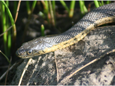
This week I was able to get out to Santa Rosa Plateau Ecological Reserve for an afternoon hike. While it is not located in Orange County, it is close by and definitely worth the trip! During my last visit to the reserve, I overheard a docent telling a group of children that, on warm spring days, the vernal pools boil with activity as the garter snakes hunt pollywogs. I am somewhat embarrassed to admit that this was the primary reason I went there this week. I lucked out and saw 2 snakes in the pools in addition to wildflowers, dragonflies and lizards.

The Santa Rosa Plateau Ecological Reserve is on 39400 Clinton Keith Road and is located at the southern end of the Santa Ana Mountains (off the I-15) between Temecula and Lake Elsinore. The Reserve consists of 8,300 acres and protects unique ecosystems like Engelmann oak woodlands, riparian wetlands, coastal sage scrub, chaparral, bunchgrass prairie and vernal pools. Day use is $2.00 per person.

There are many trails to choose from however biking and horseback riding is limited to the Sylvan Meadows Multi-Use Area. I have only been on a few trails on the reserve and they were well-maintained and mildly hilly. I also recommend stopping at the Nature Center that is staffed by knowledgeable docents. There also great exhibits and good bathrooms (which is a huge plus for me!).

Saturday, April 18, 2009

Aliso Summit Trail


Lunch Break!


Enjoying Ocean Views and Breezes


The Canyons


Thomas Guide Orange County 951 Aliso and Wood Canyon Park Map

Normally, I tend to avoid all bike trails that contain any of the following descriptors: summit, peak, ridge, view point or any references to planets or stars. Today, however, in the spirit of hoping to complete the last leg of the Mountains to Ocean ride along Aliso Creek Bikeway, I set aside my prejudices and sucked it up to tackle the Aliso Summit Trail. We ‘started’ the ride from the entrance of Aliso and Wood Canyons Wilderness park. There also appears to be some parking along Alicia, across from Laguna Niguel Regional Park.

The trail itself seems separate from the park although it is on the official park map. From the park, ride UP Alicia, turn Right on Highlands (more UP) and, at the ‘second’ Ridgeview, is the trailhead. Be prepared for about a 700 foot climb to get to the trail, even the “boy racers” were whining.

For most of its length, the 3 mile trail borders residential communities to the east and natural open space to the west with expansive views of the Aliso and Wood Canyons and the ocean. The trail primarily consists of natural and decomposed granite surfaces and, in two locations, the continuity of the trail is provided by sidewalk connections. A sidewalk along Talavera Drive and Pacific Island Drive connects Seaview Park with the start/end of the trail on Pacific Island Drive. Once on the trail, it is fairly level (yahoo!).

We may have been able to get to the coast but we were lame and not willing to give up any altitude. After reviewing maps post-ride, it seems as if there should be some way to link up the Aliso Summit Trail to the South Laguna Ridge Trail and get to the beach. That will have to be another day…

Monday, April 13, 2009

Laguna Coast Wilderness Park


Owl Clover


Trailhead and Pay Station


Enjoying the peek ocean and canyon views after the first climb


Emerald Canyon. Walking waist deep in the grass wasn't too bad until Scott shared his Jurassic Park velociraptor flashback. I started walking a bit faster.


Very fancy trail map-loop noted in pink


Blue-eyed grass in front of sticky monkey flowers


A bug gets quite friendly with the blue-eyed grass.


A lucky ladybird beetle


White lined sphinx moth


A close-up: check out his furry body!

Laguna Coast Wilderness Park is located in the San Joaquin Hills between the cities of Newport Beach, Irvine, Laguna Hills, and Laguna Beach off of Laguna Canyon Road. This park is a testament of how the efforts of concerned citizens and local and state governments can combine to preserve land for public use and more importantly to protect wildlife and their habitat from development. The park spans over 6200 acres and offers wooded canyons, a natural lake and incredible vistas of the Pacific Ocean and surrounding areas. Most of the area is limited to hiking and horseback riding but there are some mountain biking trails available and are clearly noted on the park map. Hours are 8 am to 4 pm and parking is $3.00.

There are 2 parking entrances off of Laguna Canyon Road. We parked in the lot closest to Laguna Beach and hiked up Big Bend Trail to the Old Emerald Falls Trail and then looped up and back along the Bommer Ridge Trail. It took about 3 hours round trip but that included lots of photo stops and a picnic in Emerald Canyon. The trails are quite steep in places and there were lots of climbs in and out of the canyon. At every peak, however, we were rewarded with ocean views and sea breezes. This is definitely a great quads and glutes work out!